How to Achieve Precise Geolocation?
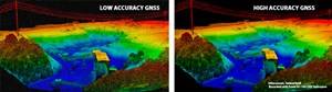
Precise Geolocation. In today’s world of precision sensors, in the air and on the ground, precise geolocation is needed more and more. INS (Inertial Navigation Systems) can achieve precise LiDAR point clouds and other sensor positioning. These point clouds rely heavily on the precise location of the payload creating the images. The more precise the location information in a 3-D space, the more precise and higher resolution your data will be. With precise geolocating, you can eliminate the need to have a crew lay out multiple ground reference points, allowing you to cut time and costs while still maintaining precise geodetic control and high resolution cloud points.
INS for LiDAR Applications.
These methods and technologies also carry over to sensors other than LiDAR. In addition to knowing where your platform is, INS, through the use of precise positioning and other sensors, will provide pitch, roll, yaw and heave to let you know exactly where your camera, LiDAR, IR sensors and even munitions are pointing. In other words, INS can help provide the location of your image on earth relative to your platform’s position automatically: This geolocates the image rather than the platform location.
Testing Your GPS Locating with Your LiDAR System.
So now that you decided to take advantage of precise geolocation by combining inertial navigation with GNSS positioning, how do you know your GPS/GNSS is working properly for your application and platform? How are you going to test your system? There are a number of GPS/GNSS simulation options available to help you debug your system right from your lab, instead of field testing. These LabSat systems from Racelogic will save you hours and hours of valuable engineering time and potentially thousands of dollars. The LabSat record and replay GPS / GNSS simulators and SatGen software perform many of the same functions and far costlier systems at a fraction of the cost. In addition to being powerful, they are also highly portable and easy to use.
Contact me for more information about using inertial navigation with GNSS for precise geolocation applications, like LIDAR and photogrammetry and the product options available for this and for testing.